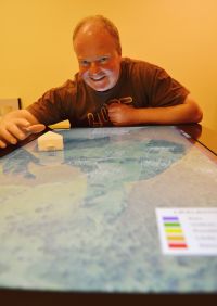
With the assistance of Tasmania Fire Service, UTAS PhD candidate with the School of Engineering and ICT Mark Brown is taking an interactive surface computer – a table-sized touchpad that can display layers of interactive maps and recognise and react to objects placed on it – to residents of bushfire-prone areas.
Because a group can stand around the interactive table and easily see a combination of critical information, such as roads and tracks, treed and cleared ground, water sources, land contours, boundaries, parks and forests – assessment of how to prepare for bushfire is being made easier.
Adding models of vehicles, buildings, water tanks or any other relevant objects automatically adjusts the information presented on the table, and feedback from the targeted groups is being used to improve the model, called the Bushfire Ready Neighbourhoods Program.
"While some people go to some effort to prepare their own property for the bushfire season, it's not always enough if neighbouring properties aren't also prepared," Brown said.
"Communities need to work together to make their whole area as safe as possible and to identify defendable zones and problem areas that need to be addressed."
One of the first areas to trial the technology was Lorinna in the North-West, which has an 8km gravel road along the side of a lake as the only way in and out.
The other towns which have taken part in initial trails as part of the research, held in the second half of last year, are Lilydale, in the north, and Ferntree, in the south.
"When there's only one access road the Tasmania Fire Service recommends that the safest option is to leave early, but if residents decide to stay and defend, their knowledge of the area and how they have worked with their neighbours in terms of effective communication networks, local equipment and developing plans could really help," Tasmania Fire Service Community Development Coordinator Peter Middleton said.
Middleton has been working with Brown in developing the software, which is also supported by NRM North, and has paved the way for community involvement and feedback.
He said that the collaborative partnership between UTAS and Tasmania Fire Service could help save lives and property in the future and that the tabletop technology is proving to be a unique tool for engaging communities.
"Our aim is to continue a series of trials around the state. The Tasmania Fire Service sees that focused community development will help enact behavioral change in communities and community members in terms of bushfire preparedness."
Brown's co-supervisor, UTAS DVC (Research) Professor Paddy Nixon, said that he was excited to see such a wonderful example of internationally significant research being taken out of the lab and having real impact in our communities.
"We are now in the middle of the most likely period for bushfires to occur in Tasmania and there's no better time to be thinking about how we can work towards improving the outcomes when they occur in the future."


-160x160-state_article-rel-cat.png)




-160x160-state_article-rel-cat.png)

